Learning geography is important to know where we are. Having a good map of Europe is a very important educational resource for getting to know our neighbors and understanding more about the continent in which we live.
There are different modalities to know each one of the characteristics and denominations of the land. In traditional shops and stationery, we can buy maps of all kinds. A political, fluvial, silent, physical map of Europe … And a long etcetera.
But since Google and the Internet have existed, we can also download the map of Europe that best suits us online and for free. Below you have a political, physical, river, silent, and many other types of maps, ready to download from the Internet and print for free.
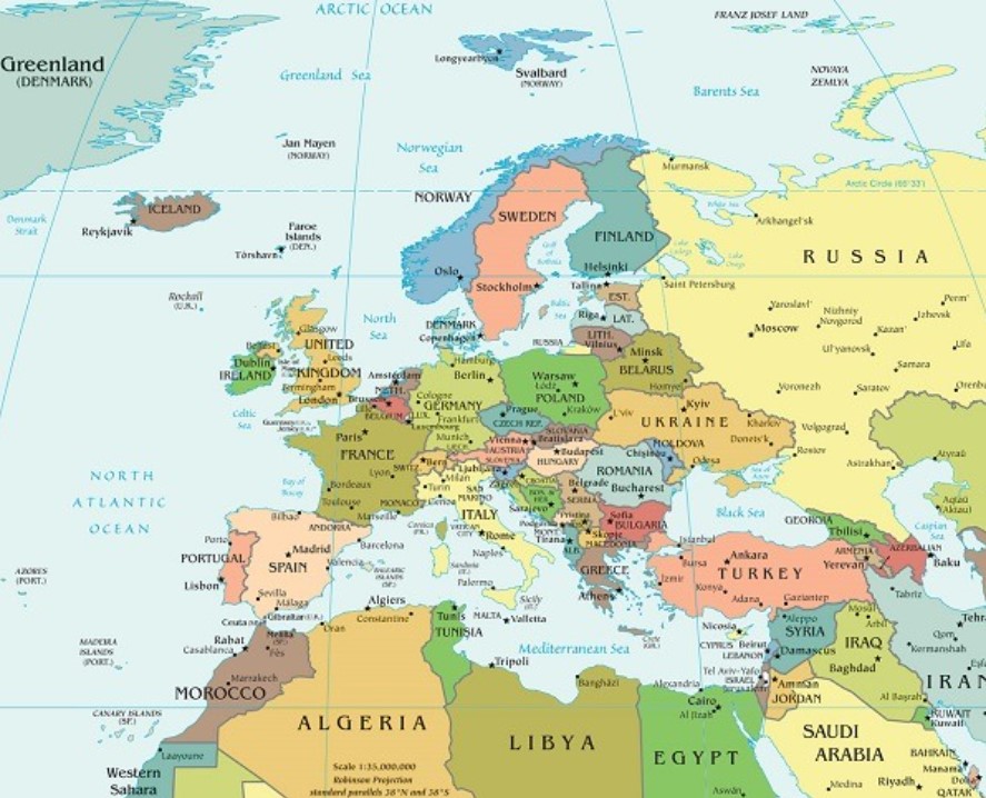
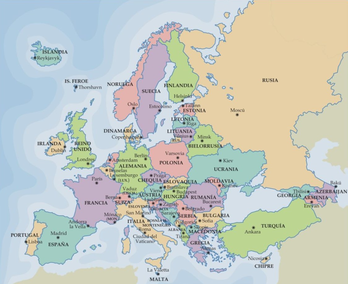
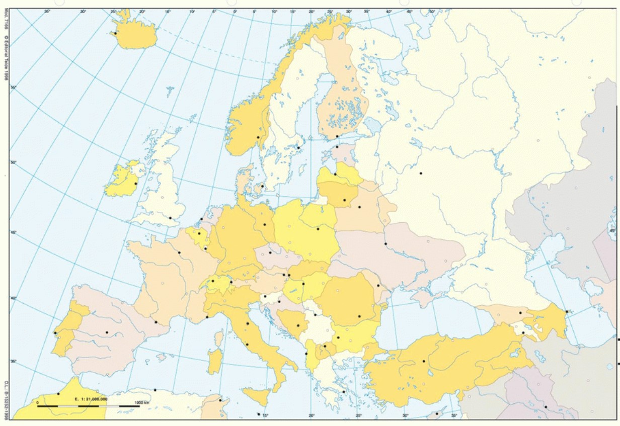
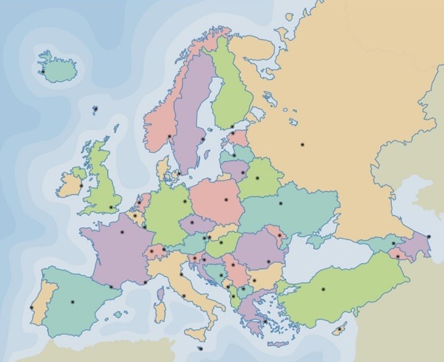
POLITICAL EUROPE MAP
Political maps are very useful for learning about countries. When we were 15 in Europe, memorizing them all could be relatively easy. But things have changed with the entry of other new countries into the European Community. You only have to watch Eurovision to remember that there are countries (excuse me) like Montenegro, Moldova, or Azerbaijan. And a lot.
In any case, if you want to find a political map of Europe that will help you locate the different countries on the map, we recommend you carry out a simple search.
Here you have ten good quality political maps you can print full pages, which will not lose quality: 1, 2, 3, 4, 5, 6, 7, 8, 9, and 10. You will see that there are colored maps with larger or smaller letters, capitals, softer or stronger colors, indications of other important cities, or, for example, with the main communication routes.
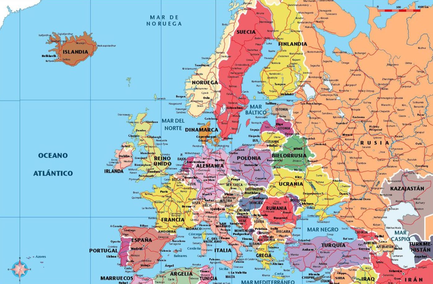
The latter is important to identify the main roads connecting some countries. It will come in handy to know the location of the countries and have a basic diagram of the connections if you travel from one place to another.
Other utilities. The political maps you have up here will be useful for studying the countries. In this way, we recommend downloading and printing the political map of Europe that you like the most. When you have learned the location of the different countries well, you can download a silent map of the ones we propose below.
Then start filling it in with the names of the countries and their capitals (if applicable). In the end, you will be able to check if you have succeeded or, on the contrary, you still have to review a little more.
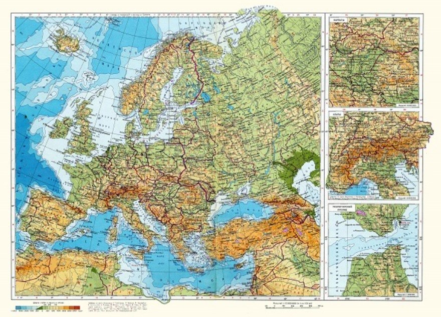
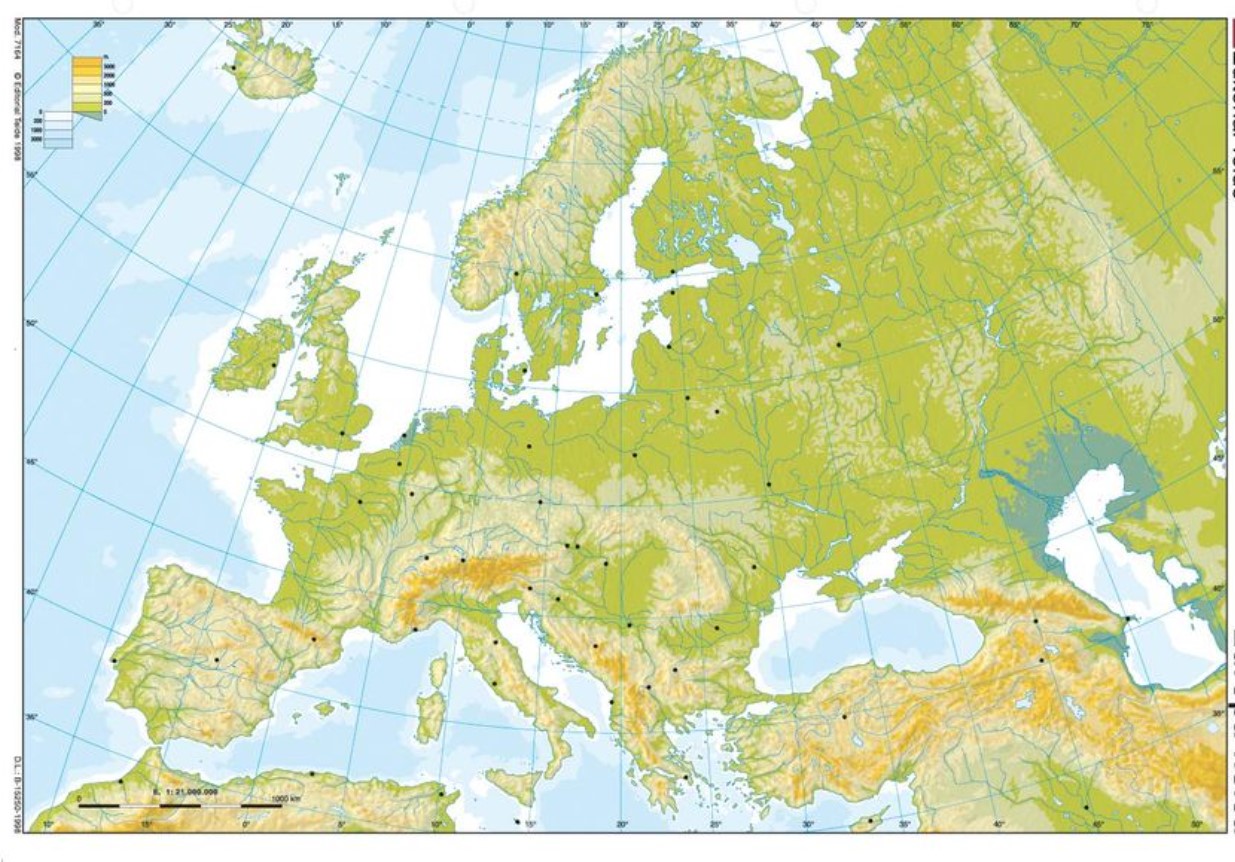
PHYSICAL MAP OF EUROPE
Do you know where the Carpathians are? Where does the Loire start? Do you have any idea where the Grampians are located? Well, it’s about time you put your batteries on. If you have a physical Europe quiz, you must download a physical Europe map right now.
Physical maps are what help us better understand the territory. It includes a large part of the natural phenomena of geology, such as rivers, mountains, or deserts. Thus, instead of seeing the different countries and capitals on the map (this would be a political map), we will observe the geological phenomena that make a territory characteristic.
Most may sound familiar to you: the Alps, the Apennines, the Balkans, Etna, the Seine, the Danube, or the Scandinavian Mountains. However, partly due to its size, Europe contains a great variety of geological realities worth learning about. This will help us to form a fairly complete idea about the composition of the terrain, the nature of the places, and even the character of its people.
Here are twenty maps with which to learn the physical geography of Europe. The top ten are in Spanish: 1, 2, 3, 4, 5, 6, 7, 8, 9, and 10. The following ten are available in English: 11, 12, 13, 14, 15, 16, 17, 18, 19 and 20.
MUTE EUROPE MAP
Are you looking for a map of Europe blank? Well, you also have it very easy, because you will find many interesting and free proposals on the Internet. Lists to download. The first thing we propose is a series of twenty silent maps of Europe in white. They are ideal for practicing recognition of different countries, as well as different capitals.
Twenty simple, high-quality maps are available to print, download, and work on. Don’t look for colors. Being white will be very useful for us to write within each region. For example, you can draw pictures to exemplify each country’s traditions or typical dishes.
You can also add flags or cultural symbols: the Eiffel Tower in the capital of France, Paris, the Wooden House in Amsterdam, or the Atomium in Brussels.
Here you have the twenty silent and white maps of Europe: 1, 2, 3, 4, 5, 6, 7, 8, 9, 10, 11, 12, 13, 14, 15, 16, 17, 18, 19 and 20. But beware, you also have the option of using color maps.
Here is a pack of ten colored blank maps of Europe. Perhaps they are more pleasant to drive than the white ones because the different countries seem more delimited. We have included some names of countries, which will be useful for you to learn the capitals: 1, 2, 3, 4, 5, 6, 7, 8, 9, and 10.
But there is another type of silent map, which have to do with geography. We have shown you the political maps, which are the ones that help us to learn about the countries and the capitals. Then there are the physicists, who help us to recognize the different geographical phenomena.
If you are studying the rivers, mountain ranges, or volcanoes scattered throughout Europe, it will be great to download a silent physical map of Europe. Next, we propose up to ten physical blank maps to recognize the different geographical phenomena: 1, 2, 3, 4, 5, 6, 7, 8, 9, and 10.
But if you are learning specifically about rivers, lakes, seas, and oceans, maybe you better download one of the following: 1, 2, 3, 4, 5, 6, 7, 8, 9, and 10. You can make notes on top, indicating the names you have memorized with the previous maps.
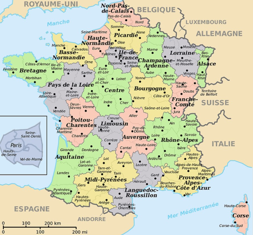
MAPS OF EUROPEAN COUNTRIES (POLITICAL, PHYSICAL AND SILENT)
The Europe we know today comprises 28 states, which has increased considerably since its founding to six. In this list, you will find all the member countries of the European Union and other territories in the same area of influence.
Thus, you can find maps of Germany, France, Portugal, Russia, and Belarus. We have tried to make the list as complete as possible so you do not have to search on Google.
Be that as it may, below we offer you the list of available countries in alphabetical order, along with three different maps: the political map, so you can identify the different cities, provinces, and regions; a physical map, which will show you the geographical phenomena of each country; and the silent map, with which you can train your knowledge about countries, capitals, rivers, and mountains…
- Albania ( political map | physical |map blank map )
- Germany ( political map | physical |map blank map )
- Andorra ( political map | physical |map blank map )
- Armenia ( political map | physical |map blank map )
- Austria ( political map | physical |map blank map )
- Azerbaijan ( political map | physical |map blank map )
- Belgium ( political map | physical |map blank map )
- Belarus ( political map | physical |map blank map )
- Bosnia and Herzegovina ( political map | physical |map blank map )
- Bulgaria ( political map | physical |map blank map )
- Cyprus ( political map | physical |map blank map )
- Croatia ( political map | physical |map blank map )
- Denmark ( political map | physical |map blank map )
- Slovakia ( political map | physical |map blank map )
- Slovenia ( political map | physical |map blank map )
- Spain ( political map | physical |map blank map )
- Estonia ( political map | physical |map blank map )
- Finland ( political map | physical |map blank map )
- France ( political map | physical |map blank map )
- Georgia ( political map | physical |map blank map )
- Greece ( political map | physical |map silent map )
- Hungary ( political map | physical |map blank map )
- Ireland ( political map | physical |map blank map )
- Iceland ( political map | physical |map blank map )
- Italy ( political map | physical |map silent map )
- Kazakhstan ( political map | physical |map blank map )
- Latvia ( political map | physical |map blank map )
- Liechtenstein ( political map | physical |map blank map )
- Lithuania ( political map | physical |map blank map )
- Luxembourg ( political map | physical |map blank map )
- Republic of Macedonia ( political map | physical |map blank map )
- Malta ( political map | physical |map blank map )
- Moldova ( political map | physical |map blank map )
- Monaco ( political map | physical |map blank map )
- Montenegro ( political map | physical |map blank map )
- Norway ( political map | physical mipmap )
- Netherlands ( political map | physical |map blank map )
- Poland ( political map | physical |map blank map )
- Portugal ( political map | physical |map silent map )
- United Kingdom ( political map | physical |map silent map )
- Czech Republic ( political map | physical |map blank map )
- Romania ( political map | physical |map blank map )
- Russia ( political map | physical |map blank map )
- San Marino ( political map | physical |map silent map )
- Serbia ( political map | physical |map silent map )
- Sweden ( political map | physical |map blank map )
- Switzerland ( political map | physical map blank )map
- Ukraine ( political map | physical |map blank map )
- Vatican City ( political map | physical |map blank map )
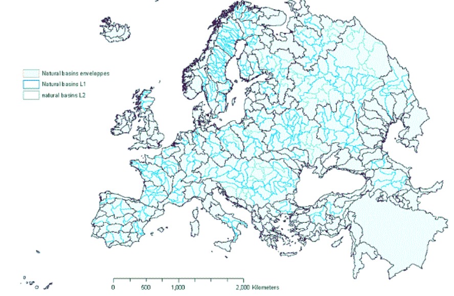
EUROPE MAP WITH RIVERS
Europe has truly impressive rivers. Some Spanish rivers are not bad, but they cannot be compared with the largest in Europe. While the Ebro and the Tagus have a length of 930 and 1,080 kilometers, large rivers such as the Danube or the Volga reach 2,860 and 3,530 kilometers, respectively.
The maps you will find here include the rivers of the countries of Europe, but also the European continent. Not surprisingly, most go through different territories to die in different oceans.
Next, a package with ten river maps of Europe: 1, 2, 3, 4, 5, 6, 7, 8, 9, and 10. We have mixed maps of all kinds so that you will find some with the names of the rivers. But you will also see that there are silent maps.
This will help you study the different denominations and practice them as often as possible. All you have to do is write on the map as you learn.
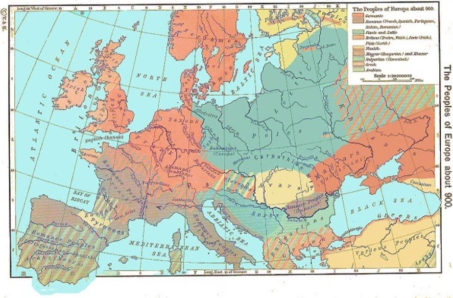
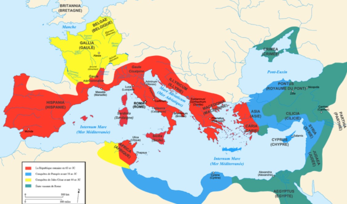
HISTORICAL MAPS OF EUROPE
The history of Europe includes a whole series of events that marked the evolution and state of the continent as we know it today. Historical maps can be of great help to understand and compose in our heads the history of the European peoples.
Thus, they are from ancient Athens, the legendary Roman Empire, the Byzantine Empire, England, the Napoleonic Empire… and a long etcetera, which ends in the current composition of our countries. A composition that is not so old either, quite the opposite.
Whether you are a student or teacher of European history, language, or popular culture, such a map of Europe can help you. They include many events, compositions, and political changes Europe has experienced over the centuries. And a lot.
Thus, maps can greatly help in understanding nationalism, times of war, the political revolution, the industrial revolution, the cold war, or the reunification of Europe and the revival of Russia. Next, a collection of 15 maps to relive the history of the European peoples: 1, 2, 3, 4, 5, 6, 7, 8, 9, 10, 11, 12, 13, 14 and 15.
EUROPE TOURIST MAPS
And what about tourism? Europe is a true paradise for pro-travelers. Spain is undoubtedly one of the favorite destinations for Europeans and foreigners. However, Europe has great jewels of nature, architecture, and gastronomy.
Landscapes that one cannot miss and that are relatively close. Half an hour by plane. In this special article about maps of Europe, we have also wanted to add the so-called tourist maps. They do not have the geopolitical rigor that we would look for in other maps, but having a map of Europe can be useful for knowing the main points of interest in each country or region.
We have found a map of Europe with tourist destinations, which will help us identify the main European capitals we can visit. And that, in one way or another, is a point of interest. Here you have a political map that offers us cities and connections, with places of pilgrimage, a route for a European getaway, and another to print with beautiful illustrations.
We have also searched for tourist maps of the main European cities. This way, if you have to go on a trip, you will not need to look any further. Here you have tourist maps of Madrid, Barcelona, Paris, Rome, Berlin, London, Amsterdam, Lisbon, Dublin, Stockholm, Oslo, Prague, Vienna, Athens, and Budapest.

MAPS OF THE LANGUAGES OF EUROPE
Although most of the countries of the European Union starting from a single language, Latin, there are countless languages from many other families. As you know, German has little to do with Italian, although the truth is that all languages have influences.
Not in vain, the European peoples have been moving from one place to another, leaving their mark everywhere. What would it be, if not these Gallicisms that we have already made so ours? Croissant, mushroom, chef, driver, plot, croquette, corset, gourmet, menu… A large part of these are part of the gastronomic lexicon. But we also have Germanisms like mustache, forest, spy, glove, distaff, and rich… Who would say so?
Well, we have prepared a whole series of very important maps showing all the Old Continent’s languages. All the European languages and dialects are defined, and here are the languages spoken in Europe today.
As there are so many interesting proposals, we offer you a package of ten linguistic maps of Europe that will delight language scholars, and that will be very useful for those who are still reviewing the languages spoken in the European Union: 1, 2, 3, 4, 5, 6, 7, 8, 9 and 10.
EUROPE MAP GAMES TO PRINT
Geography has never been easy. Except for some privileged people who enjoy learning names and locating them on the map, many of us have a terrible time identifying certain cities and countries on the map. Learning it is not easy, but we can try, even if it is with more fun and interesting strategies.
And it is that on the Internet, you will also find an infinite number of maps and games to learn the names of the countries, their location on the map, and their capitals. With your students, friends, or family, you can play to identify them, but you can also learn about these countries.
We refer, for example, to their traditions, typical dishes, most famous monuments, or spoken languages. With this colored blank map, you can play to guess the countries and the capitals, but you also have labels to know the rivers or even maps with flags to learn the one of each region.
Here you have a cutout to locate the countries on the map and puzzles with all the countries. Finally, you can cut out these flags and place them on a blank map we provided you at the beginning.