We are used to using tools like Google Maps to locate ourselves on the ground. The maps provided by Google are handy, especially when we are about to move from one place to another, to explore cities we don’t know, and to find the best routes to reach our destination as soon as possible.
The first, logically, is to study. Geography is still our pending subject, so it never hurts to look at maps and even put yourself to the test to learn how to locate the different autonomous communities, provinces, and cities. However, students and people who prefer more traditional media continue to use printed maps.
What we propose today is a series of maps that you can download and print for free. They all have good quality, so they can be used to explore Spain community by community, province by province. We will offer you a specific section so that you can download maps of each of the communities with their corresponding areas: Andalusia (Almería, Cádiz, Córdoba, Granada, Huelva, Jaén, Málaga, Seville); Aragon (Huesca, Teruel, Zaragoza); Asturias (Oviedo); Balearic Islands (Palma de Mallorca), Canary Islands (Santa Cruz de Tenerife, Las Palmas de Gran Canaria); Cantabria (Santander); Castilla la Mancha (Albacete, Ciudad Real, Cuenca, Guadalajara, Toledo); Castilla y León (Ávila, Burgos, León, Salamanca, Segovia, Soria, Valladolid, Zamora); Catalonia (Barcelona, Girona, Lleida, Tarragona); Valencian Community (Alicante, Castellón de la Plana, Valencia); Extremadura (Badajoz, Cáceres); Galicia (La Coruña, Lugo, Orense, Pontevedra); Madrid; Murcia; Navarre (Pamplona); Basque Country (Bilbao, San Sebastián, Vitoria) and La Rioja (Logroño).
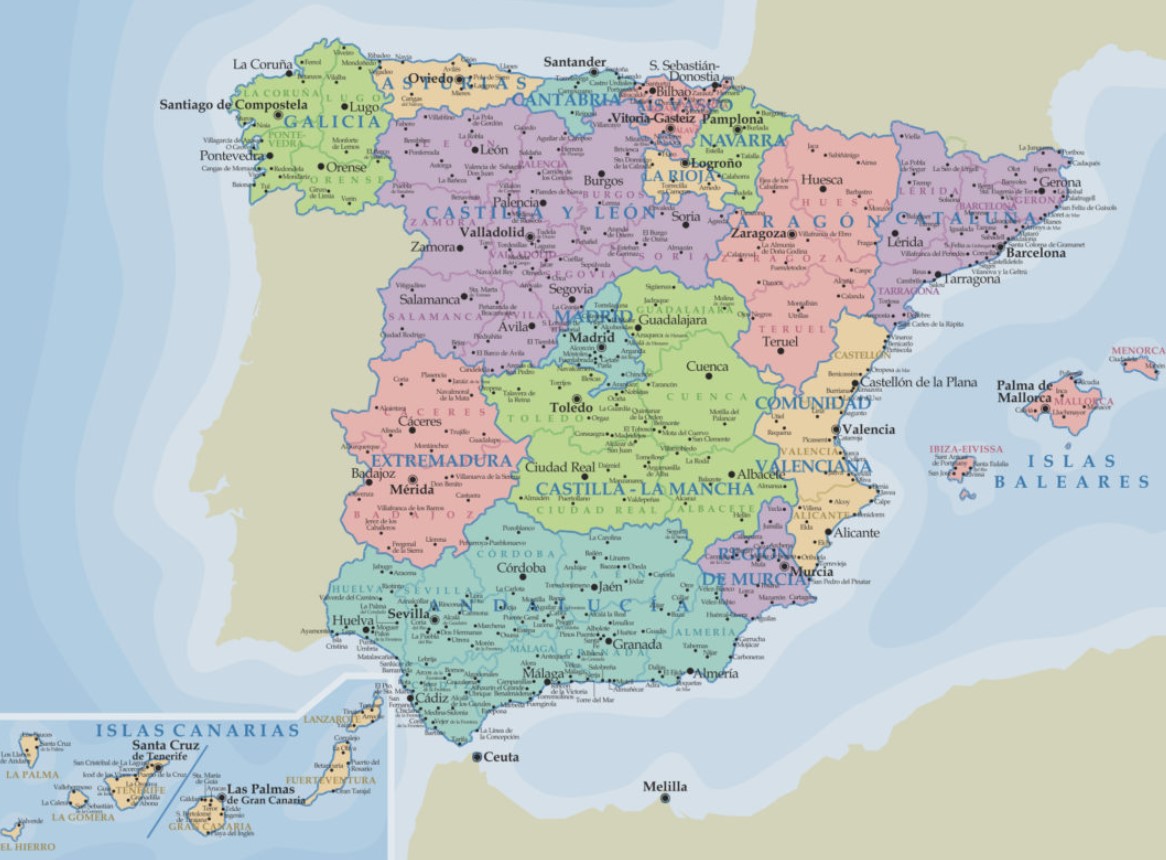
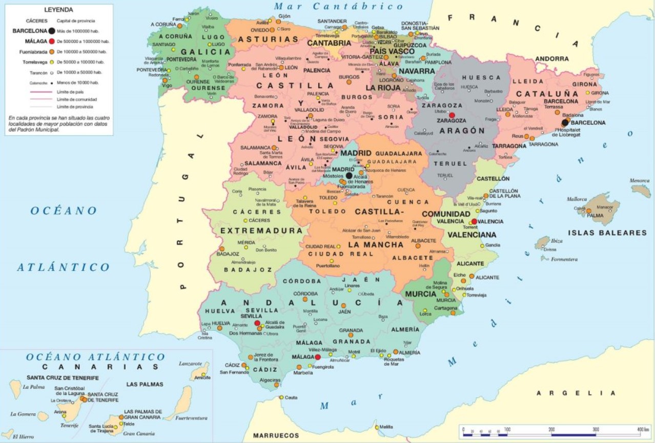
POLITICAL SPAIN MAPS
We will start with the political maps. These offer divisions and political organizations of territory, both countries, cities, or provinces. On the other hand, it is possible that the political maps we download also include information on routes, communication routes, highways, and other issues, which can also be revealed in tourist maps.
What we propose below is a collection of twenty quality political maps of Spain that you can download and print: 1, 2, 3, 4, 5, 6, 7, 8, 9, 10, 11, 12, 13, 14, 15, 16, 17, 18, 19 and 20. Usually, these maps are delimited and typically have different areas, communities, or countries differentiated by colors. In addition, the capitals generally are represented, so they are perfect for studying.
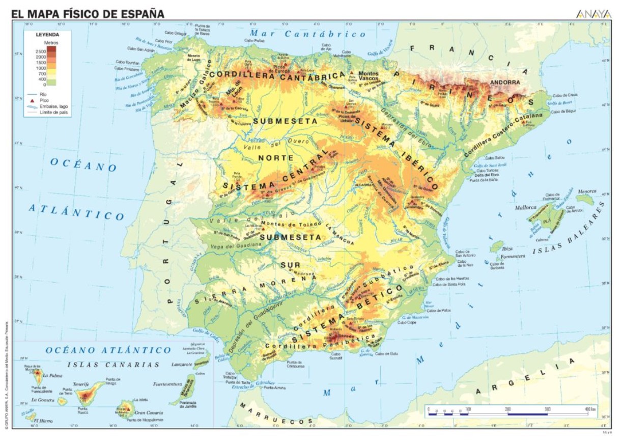
PHYSICAL MAPS OF SPAIN
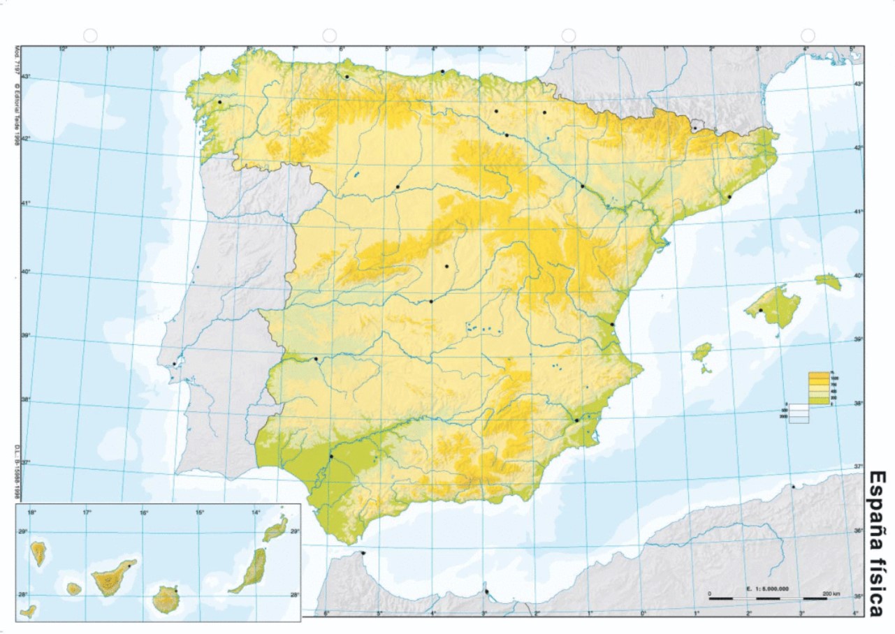
Let’s continue with the maps of Spain but in this physical case. As you know, physical maps are those on which the features of the earth’s surface are represented. We refer to rivers, the type of terrain, its height, and, on the other hand, the seabed.
The terrain’s natural features, such as rivers, mountains, and deserts, are also represented here. Usually, these appear on the map in different colors to indicate the other phenomena. But they also do it in different intensities. In this way, the altitudes of the terrain and the depth of the sea can be indicated, depending on whether they are the surroundings of the coast or the ocean.
The dark green color is used to represent depressions in the terrain, while the lighter green is used to indicate plains. We go to yellow for the plateaus, and as the altitude increases, we go from orange for the sierras, brown for the mountains, and darker brown for the cordilleras. The blue and light blue tones are reserved for the water in rivers and lakes.
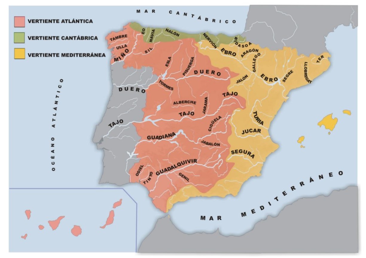
The physical maps of Spain will be great for learning about our country on the ground. You have, for example, the rivers (Ebro, Tagus, Guadiana, Guadalquivir, Duero, Miño, Segura, Júcar…). To get started, we recommend you download these 20 maps of Spain with rivers, some silent so that you can practice the names of the rivers and their tributaries: 1, 2, 3, 4, 5, 6, 7, 8, 9, 10, 11, 12, 13, 14, 15, 16, 17, 18, 19 and 20.
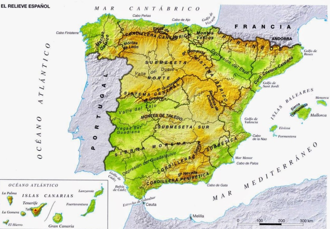
On the maps, you will also find the seas (Cantabrian, Mediterranean) and ocean (Atlantic), the sub-plateaus (North and South), the Galician Massif, the Cantabrian Mountains, the Basque Mountains, the Pyrenees, the Iberian System, the Ebro Depression, the Serranía de Cuenca, the Montes de Toledo, the Tagus Valley, Las Vegas del Guadiana, Sierra Morena, the Guadalquivir Depression, Sierra Nevada, Sierra Segura, the Penibética Mountain Range or the Catalan Coastal Mountain Range.
The gulfs and capes of the peninsula are also represented here, such as the Gulf of Roses, the Gulf of Sant Jordi, the Gulf of Valencia, the Cabo de la Nao, the Mar Menor, and the Cabo de Palos, the Cabo de Gata, the Strait of Gibraltar, the Bay and the Gulf of Cadiz, Cape Finisterre, Cape Peñas, Cabo de Ajo or the Bay of Biscay. Obviously, in most of these maps, the islands, which are the Balearic Islands and the Canary Islands, are also represented, with all their features on the ground.
We offer twenty if you want to download a map that includes all these characteristics that make our country so particular. Here you have them all: 1, 2, 3, 4, 5, 6, 7, 8, 9, 10, 11, 12, 13, 14, 15, 16, 17, 18, 19 and 20. Some are also mute so that you can practice on a blank canvas of the territory after studying physical Spain.
MAPS OF SPAIN BY AUTONOMOUS COMMUNITIES
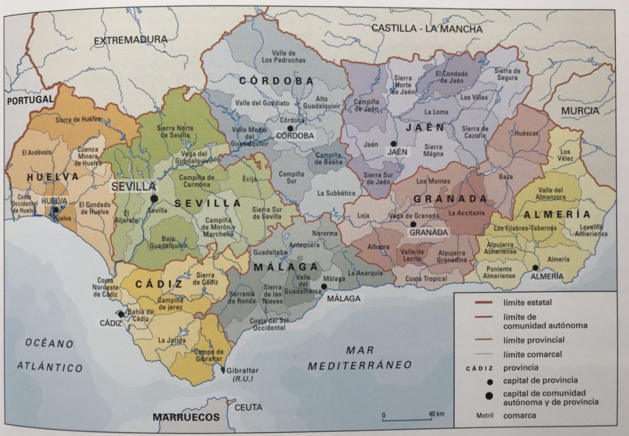
- Andalusia. We start with one of the wealthiest communities in our country, culturally, architecturally, and gastronomically: Andalusia. On the internet, you can find a good number of exciting maps to download, which are the following: the first map is complete because it contains all the provinces and regions of Andalusia, this other one also contains the sections and can be great for school exercises, this one contains infinite populations and areas of interest, so that it can be handy to use as a tourist map, and this one contains the roads. We have also found a map that includes comprehensive information on the biodiversity of Andalusia, a map of landscape areas of Andalusia, of natural spaces and botanical gardens, and finally, another with the provinces and Andalusian regions, very useful to learn them or to consult them.
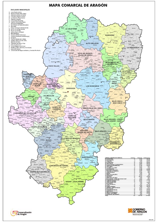
- Aragon. Let’s continue now with Aragon. Whether you will travel to Zaragoza, Teruel, or Huesca, or if you want to study all the counties and municipalities of this autonomous community, this first map will come in handy. It contains a large amount of political information so that you do not get lost in any case. Here you also have a map with the roads of Aragon, another regional one with a relief background, one with the central regions, a simpler one with the three provinces, the linguistic map of Aragon, and the map of the rural Aragonese network.
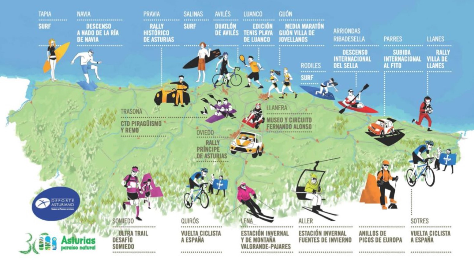
- Asturias. We travel to Asturias to offer you a collection of exciting maps to download and print if necessary. This is a simple map of the Principality of Asturias, with information on the main towns. Here you have Asturian provinces and villages, a political map useful for your trips, or a regional map. And finally, here is a map of outdoor activities and sports you can enjoy in the Principality.
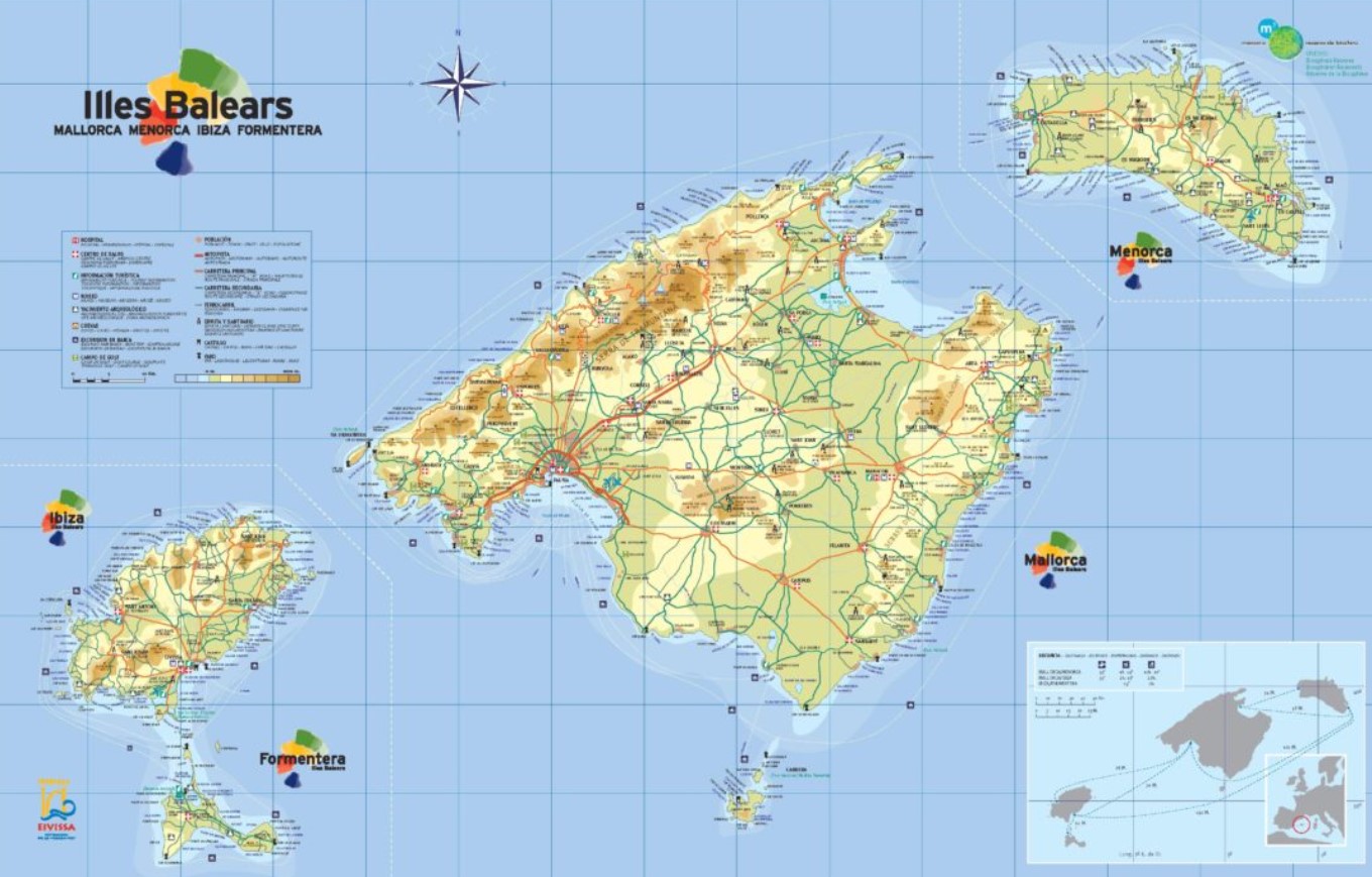
- Balearic Islands. If you were looking for maps of the Balearic Islands, here we will provide you with a few, which you can consult and print as needed. The first is a complete map containing exhaustive information about the islands, with roads, links, and the most important towns. It is an essential guide if you travel to the Balearic Islands. This contains the central municipalities of Ibiza, Mallorca, Menorca, and Formentera. We also provide you with a family tourism map, which is very useful for family excursions and outings, a silent map, and a graphic one with some of the most popular destinations.
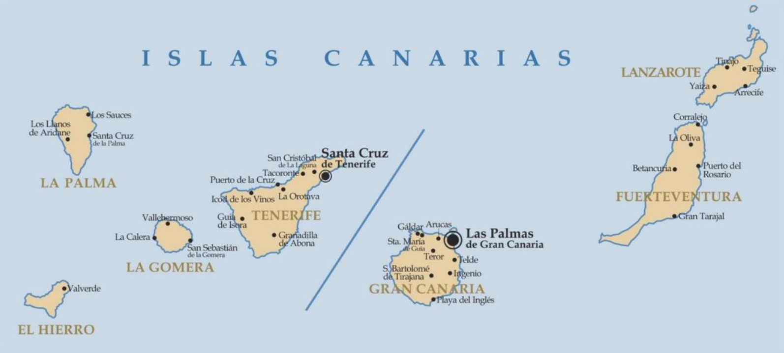 Canary Islands. Let’s start with a simple and classic map of the Canary Islands, where you will find all the information you need to travel there or ask questions about the Cabildo locations. We have another map with the main towns, a silent map to identify the islands and locate the different municipalities ideal for students, a very clear and complete one with the main cities and provinces, and one only of provinces, with their corresponding capitals.
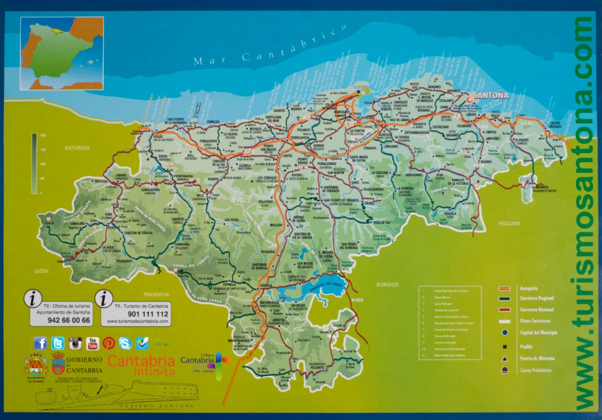
- Cantabria. Cantabria is one of our most beautiful communities, so if you want to visit it, don’t waste time downloading and printing this Infinite Cantabria map. It has all the information you need to move around all the provinces and municipalities of this beautiful autonomous community. We also propose a map in gray that is much simpler but with the information you need; here, you have information about the regions, a map of the Government of Cantabria that includes all the roads in the territory, and another with different municipalities.

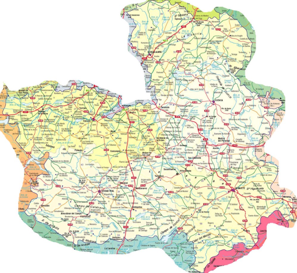
- Castile-La Mancha. Let’s start with this reasonably complete map of Castilla-La Mancha, which includes information on roads, provinces, municipalities, and critical natural areas. This includes all the streets to move around the community and its regions, the map with the employment offices of Castilla-La Mancha, a map with spaces to locate the different municipalities, a simple map with the areas, a silent map to find the localities in the territory and one that collects information on the rural development of Castilla-La Mancha.
- Castile and Leon. Let’s start with this political map of Castilla y León, where you will find information about the different provinces and towns. It is a detailed map, but enough to locate you. Here you have the central regions in bright colors, a relief map of the community, a map with the main roads, and another mute on you to place the different areas and capitals on it. Here you have other regions, a forest utility map, and another with the CAP regions.
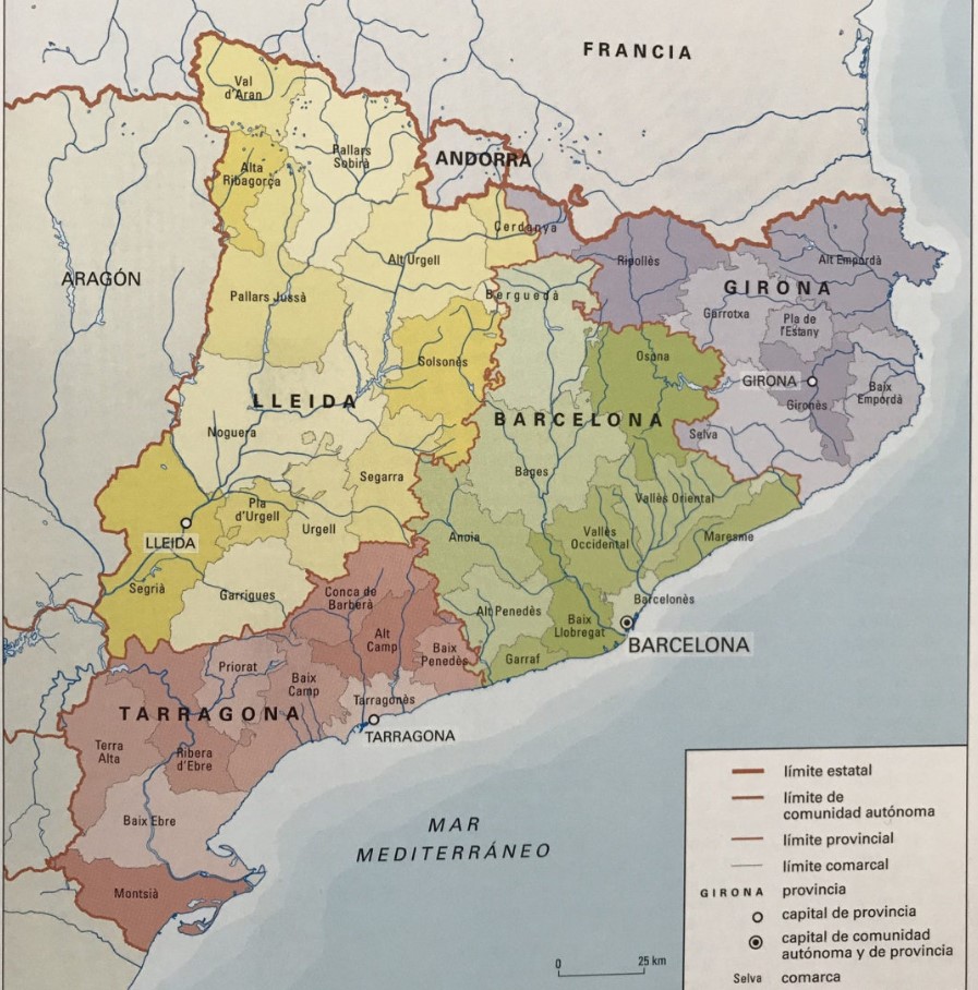
- Catalonia. Catalonia is an autonomous community with four provinces: Lleida, Barcelona, Girona, and Tarragona. Do you plan to travel here for sightseeing? Do you need maps to guide you through any of these provinces? Well, we are going to provide you with some interesting maps. First is a physical and political map in which you will find the four areas and regions. This includes all the counties and probably looks much more current. It is easy to understand at first glance. You also have a road map, which is very useful for travel. Finally, we provide you with a silent and colored map so that you can locate the most critical places in Catalonia on the territory.
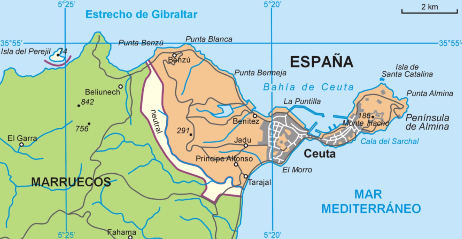
- Ceuta. Now we propose a trip to Ceuta. A journey through the maps, of course. One of the most interesting is this because it will be great for sightseeing in this autonomous city. Here you also have a map of Ceuta, which includes Isla Perejil. This other one is a map that consists of the accesses to the port, another prepared by the Ministry of the Interior for the protection of birds, and finally, one in which you can find the most exciting enclaves of the city, as well as the museums and others points of interest to visit.
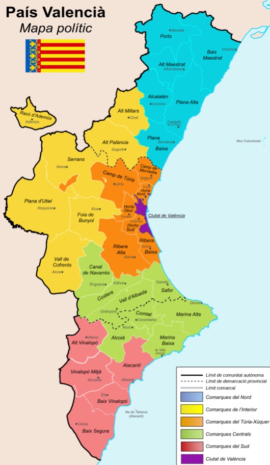
- Valencian Community. Let’s start with the first political map, prominent and colorful, of the Valencian Community. In this, we find all the information – classified by colors, which is not bad – for the North, Interior, Túria-Xúquer, Central, South, and City regions. It is an excellent quality map. We also have a silent map if you feel like testing your knowledge after learning all the Valencian areas and counties. We invite you to look at this other map on ornithological tourism in the Valencian Community. We also have another super complete with all the municipalities, including roads, which will be great for doing routes on the ground. Finally, we propose a relatively detailed map of the city of Valencia.
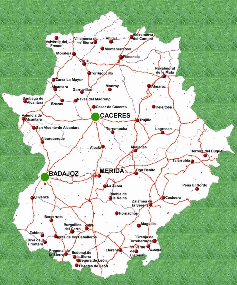
- Extremadura. Because the truth is that between Mérida and Cáceres, we can find great historical wonders. Now let’s travel to Extremadura, an autonomous community where you can also do good tourism. Let’s start now with this map of Extremadura, in which, in addition to seeing the central municipalities, you will have the option of exploring the main roads that connect. This is a physical map of Extremadura and another in which you can see this territory’s main areas and geographical features. Although if you are looking for more quality, perhaps this other map can be better for you. Although if what you are looking for is a slightly more playful and touristic map, You will be interested in discovering this other, in which you have summarized such exciting things about the territory as the cherries from Valle del Jerte, Pimentón de la Vera or Torta del Cásar.
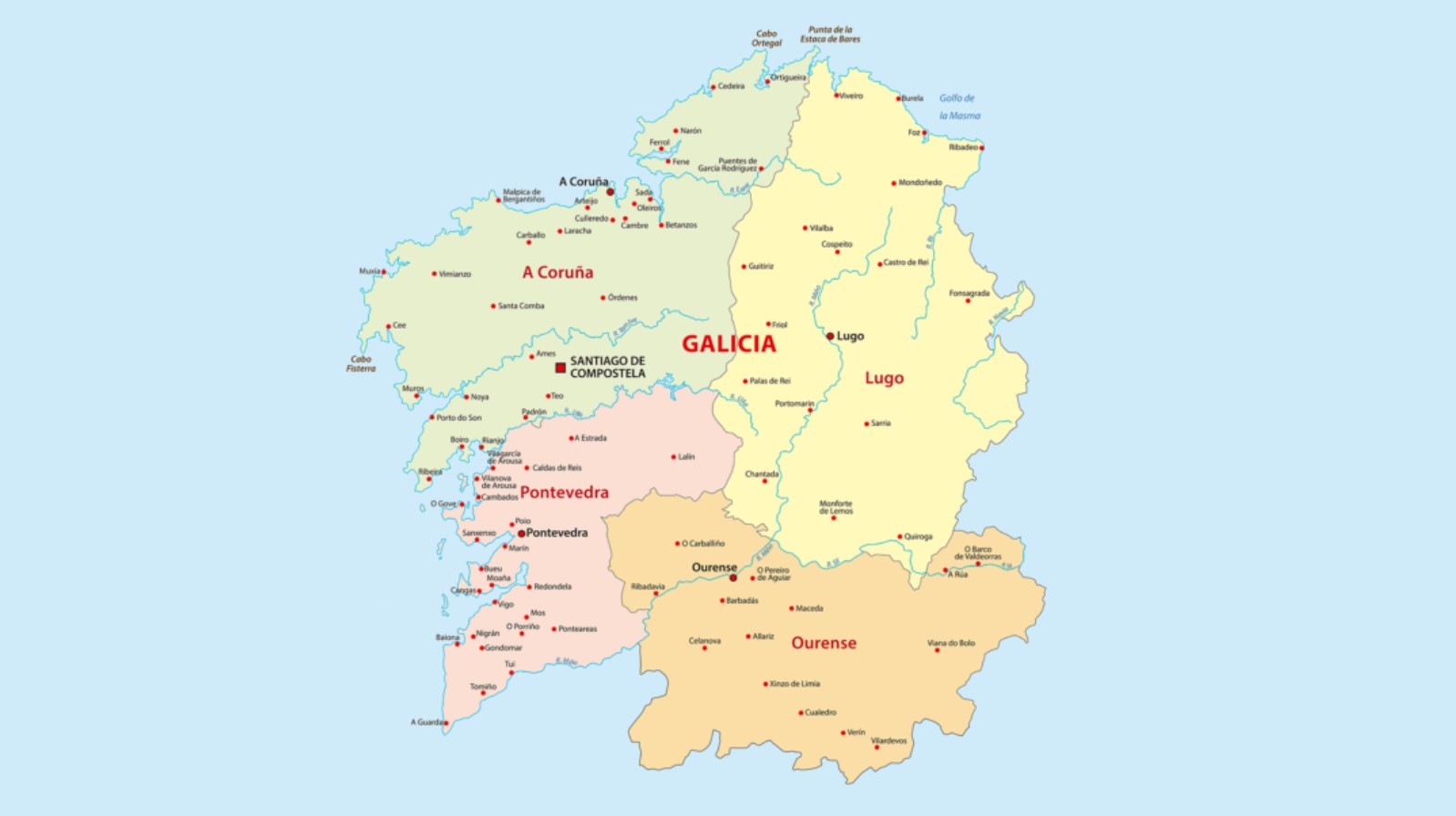
- Galicia. We go a little further up, to the North, to Galicia. We propose a map showing Galicia, with its four provinces (Ourense, Pontevedra, Lugo, and A Coruña). Then we have a map with the main roads, one of Galicia in Roman times (in case you need a historical map), and another with the Galician regions. We also offer you a complete map of the provinces and counties of Galicia and, finally, a blank map that you can use to test your knowledge after studying the regions and counties.
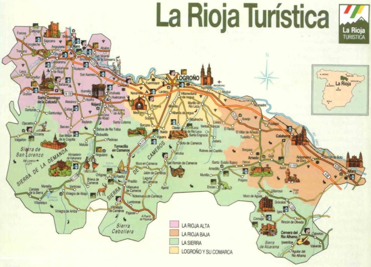
- La Rioja. We will start with the maps of La Rioja with a tourist map, which is ideal if you plan to visit this autonomous community. We also have a road map, one with the central counties and municipalities, more counties and cities, one with information on wines (we must not lose sight of the fact that we are precisely in the land of wines), one with the leading family wineries and another physical of relief, which will interest you to know the main characteristics of the terrain.
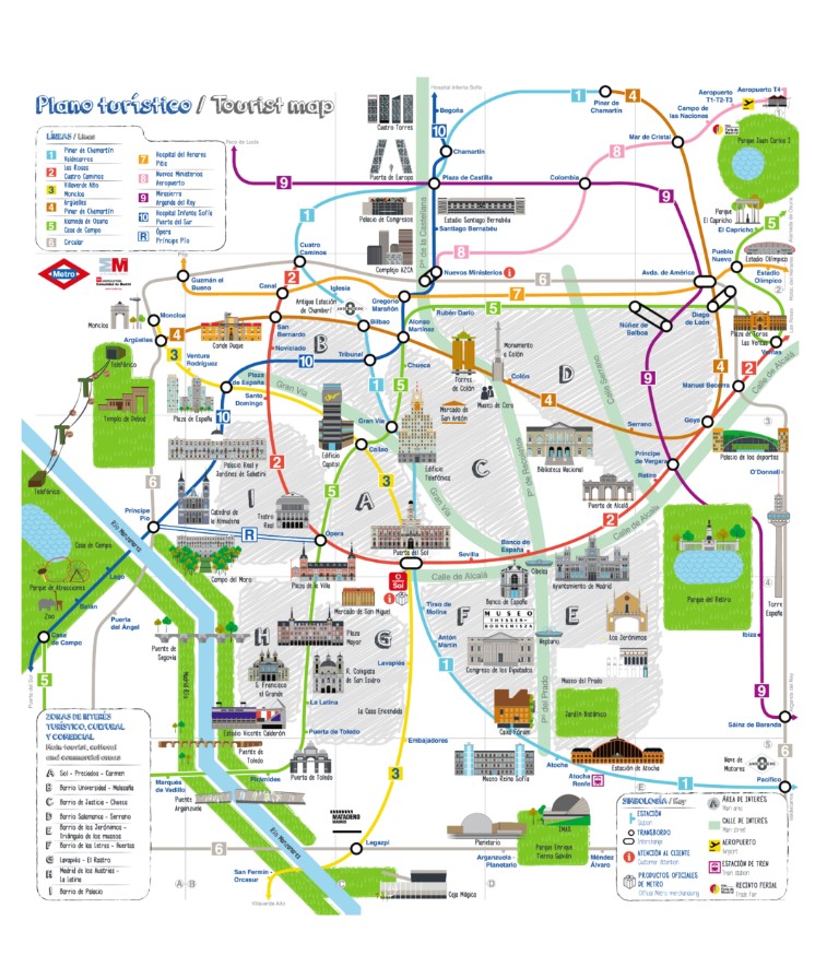
- Madrid. And now, we go for the maps of the capital and the Autonomous Community of Madrid, in the country’s center. We have found a Madrid tourist map that is perfect for those who wish to visit the capital, a map with the main roads and communications, a complete map of the central bicycle communications through the big city, a map of the entire community, the political map of the Community of Madrid, the regional map of the community, a map with the most critical areas and towns in Madrid and in case you are curious, here is an aHistorical map, exciting on the public roads of Madrid.
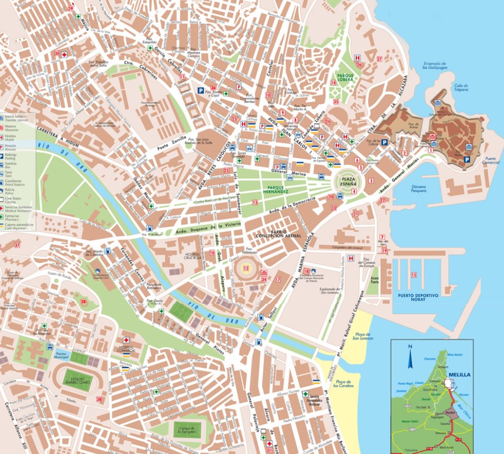
- Melilla. We now go to another important city, which is none other than Melilla. The autonomous city also offers us many interesting points to visit, so we propose a map of the town where you can see the main streets and the most critical issues. This map will help you locate Melilla on the territory and this other. If you also travel there, we suggest this other map, where you will see some interesting points from this city.
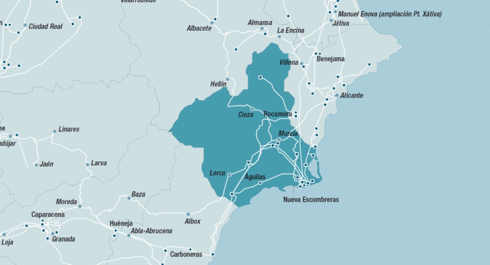
- Murcia. Let’s continue now in Murcia, a community of which we will propose a first map, a little more general and in which other nearby regions appear. Here we have another map with the central municipalities of Murcia, a map of the municipality of Murcia, different cities and municipalities in the community, a physical map with some main roads, and a map that includes Murcia, Almería, and Alicante.
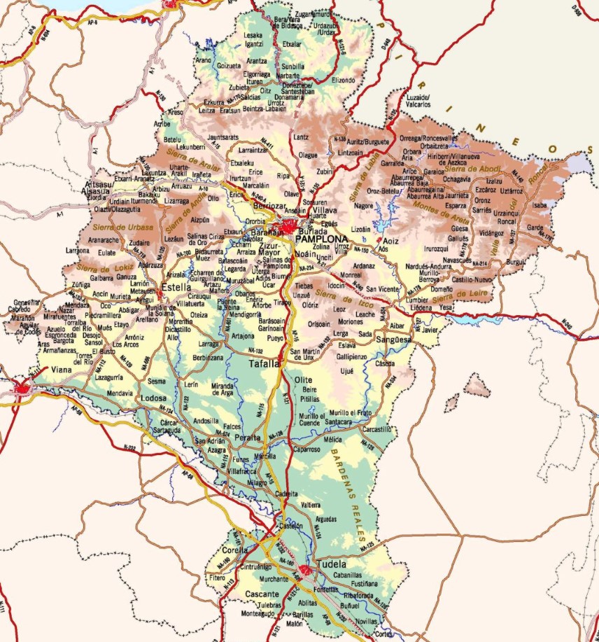
- Navarre. A little further north, we will go to Navarra to find some interesting maps to print. The first is a very detailed map, with physical details, roads, and the central municipalities of Navarra, including capitals but also small towns. We also have a map with the regions of Navarra, in this case, made in very bright colors and transparent. Let’s continue with a specific road map of Navarra, a tourist map with the main areas of Navarra, a cartographic map, a map of tourist routes through Navarra, another very complete topographic map, all the roads in Navarra, and here a distribution map of the Navarre counties.
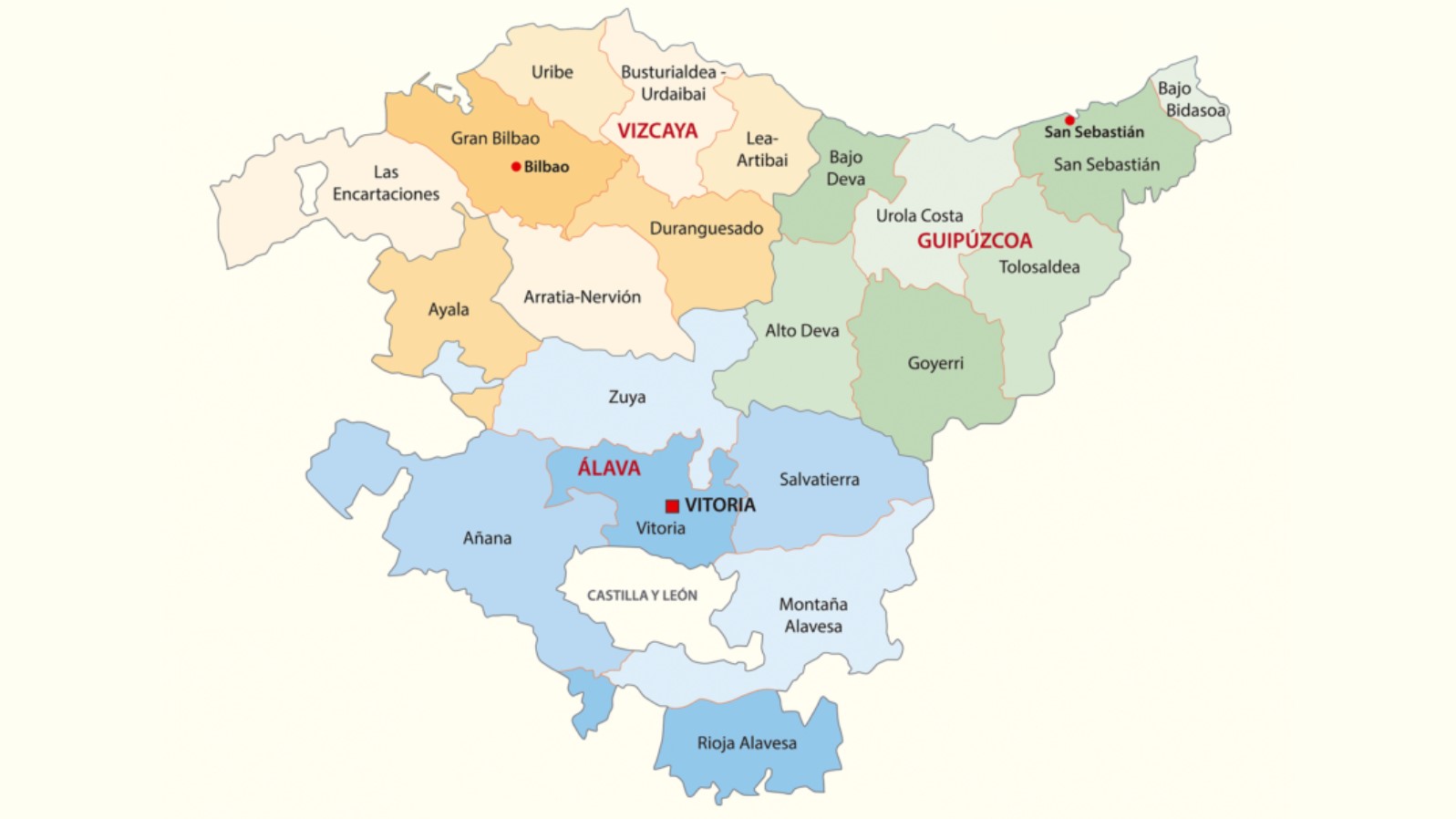
- Basque Country. The last autonomous community for which we are going to propose maps is the Basque Country. The first is very complete and contains all the provinces of this community. We have another map that can be very interesting from a tourist point of view, a very complete one with plenty of information on municipalities and roads, a map with the three provinces (Bilbao, San Sebastián and Álava), another political map of the Basque Country, a road map, a map with the provinces. We end up with another map, greenways in the Basque Country, perfect if you intend to explore this community following these paths.
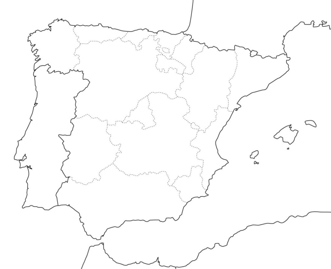
DUMB MAPS OF SPAIN
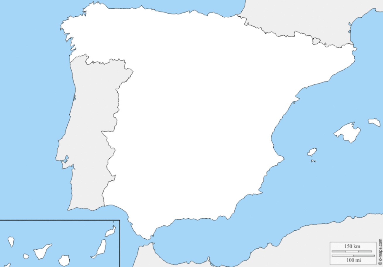
What use are maps when they contain no information? You will have deduced that we are talking about the so-called ‘dumb maps .’These are super useful for students because after reviewing and memorizing the political or physical maps, they can use these models to write all the provinces, capitals, rivers, or mountain systems on paper.
Most of these silent maps of Spain are made in very light or neutral colors, so it is easy to complete the information by hand about each region, which is usually perfectly limited. In this way, it is straightforward to use them and beneficial.
What we propose below is a total of twenty silent maps, both political and physical, of excellent quality, which you can use to review through your computer, but which will be much more helpful if you download and print them. Whatever you do, we provide them all for you here:
- Twenty silent political maps of Spain. 1, 2, 3, 4, 5, 6, 7, 8, 9, 10, 11, 12, 13, 14, 15, 16, 17, 18, 19 and 20. They will be great for learning and practicing knowledge about the Spanish autonomous communities, the different provinces that make them up, and their cities, which are capitals.
- Twenty silent physical maps of Spain. If you still don’t know the rivers of Spain or have difficulty pointing out the different ranges and mountain ranges, a blank physical map of Spain will be handy. We have tried to choose other maps so you can practice all the existing geographical accidents in our peninsula. 1, 2, 3, 4, 5, 6, 7, 8, 9, 10, 11, 12, 13, 14, 15, 16, 17, 18, 19 and 20.
We also suggest a dozen blank, silent maps of Spain so that you can use them most helpfully: to make graphs and indicate provinces, cities, languages, or typical foods. They are 1, 2, 3, 4, 5, 6, 7, 8, 9, and 10.
FUN GAMES AND MAPS TO PRINT
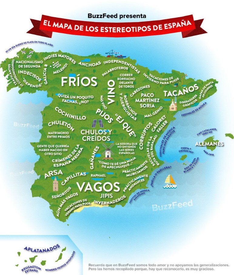
Let’s continue, finally, with one last proposal so that the smallest of the house – and perhaps those who are not so much too – are encouraged to learn the different autonomous communities, provinces, capitals, and geographical phenomena of Spain. An excellent way to do it is through games, so we offer you exciting and fun map games to download and print. We have also tried to include here a collection of funny maps in which Spanish customs and stereotypes are collected, and jokes are made about the character of the Spanish in the different provinces.
Some even include the most typical gastronomic products or the most famous monuments. Here we also propose a cut-out with which you can learn all the provinces in a more agile and fun way and an illustrated map of Spain full of curiosities.

I am a writer with eight years of experience writing in business and technology. I always carry a passion for learning and discovering new knowledge.